Trekking Package

Solukhumbu Trekking
From Kathmandu by jeep or by flight
Phaplu (Solu Sallery)

Hilepani continue road climbing uphill Ketuke, Mane Bhanjyang Okhaldhungga Thade and Tordke.
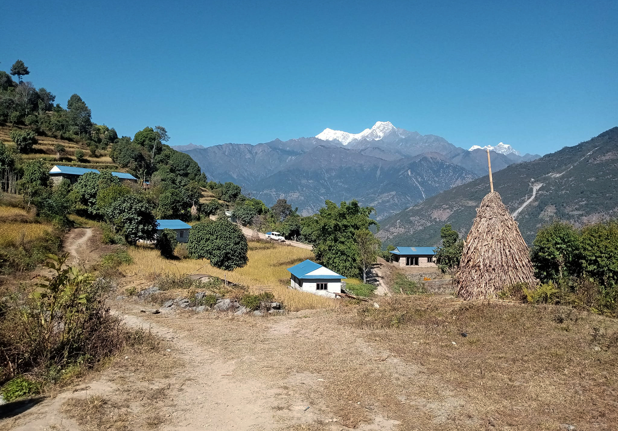
District of Solu-Khumbu Jantar dhap high altitude (3200m) from here you can see best of point view Mount Everest, Lhotse, Nuptse, Makalu, Kanchanjunga and Numbur Himal. Continue the road descend downhill Solukhola cross new bridge to Salleri Bazaar. From Solu salleri road continue uphill to Mulkharka danda (pass) from here you will get such a beautiful view point Mount Everest and Numbur Himal, also you can see unbelievable wonderful valley terraces, villages. Khaling Rai village of Kaku, Basa, Rapcha (Khali) this is your only opportunity along this to see a settlement of these people who populate so much of eastern Nepal. The British found the Rai to excellent soldiers and actively recruited them Gorkhas. Inhabited by Khaling Rai, Chhetri, Bhaman, Magar, Tamang, Sherpa, Bishokarma, Damai (Nepali) and Newar in this valley.
Departure from Kathmandu directly by jeep beyond take road of the Bhaktapur, Banepa and south of Dhulikhel from here you can see unforgettable views point westnorth, Ganesh Himal, northeast Langtang, Dorjie Lakpa and northeast Gauri shangkhar Himal. The road goes continue down hill beautifull valley, terraces, Village. District of Sindhuli continue the road descend hill to Bhakunde beshi and you can see Roshi khola R/bank always following roads Roshi khola to Nepal thok Sun koshi river and Roshi khola join there. Following always Sunkoshi river L/bank Beni ghat Sunkoshi and Tama koshi river join here. District of Udayapur Ghurmi bazzar continue road following Sunkoshi river L/bank to Tokshell ghat and you can cross the Sunkoshi bridge. District of Okhaldhungga

TO LOWER SOLU AND EVEREST TREKKING
From Rapcha (Khali) village the trail descends to the Northeast Magar, Khaling Rai and Bishokarma village of Thulodhunga Adheri. Beyond descend, Past terraces in the village to emerge at a new bridge over Dhudh Kosi river from Rapcha Khali. The trail crosses the river northeast (L) bank and heads north to reach Namche Bazaar in three days. Sometimes the trail is over a mile above the river, which falls through a steep gorge. This part of Lower Solu-Khumbu is called and Pharak there have been many improvements in agriculture in Pharak Surke, Chaurikharka Chhoplung, Ghat, Phakding, Chhutawa, Monjo, Jorshalle over the year.
You many notice fruit trees and many varieties of vegetables, The main trail north of here is being continuously improve and very busy from here.Following the river for a while through forest, then climb through terraces to reach the Khaling Rai village of Jubing. Climb through the village, round a ridge and aim for the prominent notch in front of you. From the notch contour to the village of Kharikhola inhabited by Magar, Sherpa and Khaling Rai. Kharikhola is ½ hours from Jubing. Magar hail from western part of Nepal, settling here generations ago. They no longer speak their native language. Cross the bridge over the Kharikhola take the (R) bank through the scattered settlement of Gumba Danda. The trail continues to climb through this tributary valley into prickly leave oak and rhododendron forest where languor monkeys may be occasionally seen.
At this point, you are almost a mile above the Dudh Kosi.Unlike the gorge of the Kaligandaki in central Nepal, you pass well above the steep slopes.The next tributary valley to the north has to be traversed, descend and cross the tributary after continue on the north side of the valley to reach Paiyan. Continue to the crest of ridge Chutok La leading down to the Dhudhkosi and again enter the valley of another tributary. Shortly after beginning of steep you can see the airplane landing at Lukla airport, almost due north as well as the sacred mountain khumbiyula at the head of the valley. The village of Surke at the bridge crossing the tributary below is from Paiyan. The trail now leaves this tributary valley and heads more directly north toward the village of Chaurikharka, another scattered village. Along the way to pass Lukla is half hour beyond Surke.
This junction is just before the main trail crosses a stream on a small cantilever bridge. The air field is reached in an hour from here. Before ascending to Chaurikharka the main trail crosses a spectacular deep gorge with a high waterfall. Upper Chaurikharka with three large stupas and gomba, is ½ hour from Surke. From here on going is easier. The major climbs are over. The trail from Chaurikharka (Which means pastures for Yak-Cow cross-breeds) passes through pleasant fields and ascends to a small ridge where the trail to the north from Lukla joins the main trail up the Dudhkosi valley Chhoplung, a newly built town is half hour from Chaurikharka. Lukla (2850m) has become a major trekking center over the years,
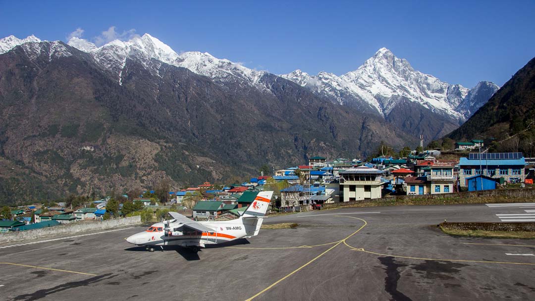
The name of Lukla means “place with many goats and deep” but clearly things have changed! in addition to the airstrip nestled among spectacular mountains, there are many hotels featuring food and accommodations varying from slightly more expensive than cheapest in nearby places to quite luxurious and of course, expensive. To proceed from there, head north another tributary (2698m) with a beautiful peak at its head. Soon come to a bridge over the Dudh Kosi with village of Ghat (2545m) on both banks. There are hotels proceed on the east (L) bank through the Phakding (2652m), now expanded both sides of the river.
Phakding is ½ hours from Chhoplung and 2/5 hours form Lukla. Here cross to (2621m) of Dudhkosi. Continue blue pine and rhododendron forest to village of Benkar (2905m), which is reached in an hour from Phakding. Watch for large, hanging, Tongue-like beehives just beyond a waterfall on the east (L) bank Clift opposite you in this steep walled canyon. In a short while cross to the east (L) bank and climb up through Chhumowa. Here you may notice extensive vegetable farms as well as supply hotels and restaurant. The vegetable grown here are excellent. Cross another tributary, the Kyangshar khola (2773m), before climbing up a Clift in the canyon wall to Monzo (2835m) about forty-five minutes from Benkar. The trails descends in a cleft to the left of a huge rock and crosses to the west (R) bank of the Dudhkosi on a large suspension bridge to reach Jorsale (2774m) in forty five minutes. This is the last village before Namche Bazaar. Enter Sagarmatha (Everest) national park here and pay the entrance fee. You can see the route on the Khumbu Himal map of research scheme Nepal Himalaya. Jorsale is called Thumbug on this map. Continue of the west bankthrough blue pine forest to reach the confluence of the Bhote Kosi from the west and the Dudh kosi form the east.
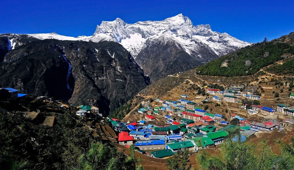
The east fork is crossed (2843m) to its east (L) bank and the climb to Namche bazaar begins. Some (152m) up the crest of the prow; Everest can be seen behind the Lhotse-Nuptse ridge. Water has even been piped to this point. Namche bazaar (3446m) is 2 or 3 hours from Jorsale.
You are now in Khumbu. Sherpas run the stores, hotels and restaurants. Prices are high but most staples are available. Old expedition food and equipment and available in the shops. The head quarters of the Sagarmatha National Park is in Namche bazaar with an excellent museum on the hill to the east. General regulations of the national parks esbespeak the extensive forest that once existed here. Continue to the river, Imja khola and cross it at narrowing on a suspension bridge (3780m) from which you get a spectacular view of Ama Dablam. Cross to the north (R) bank. Some five or ten minutes beyond, near mane stones, the trail forks. The left (Higher) fork ascends to the Pangboche Gomba (3985m), while the right goes directly to village of Pangboche (3901m) some 1/5 half hour from Tengboche. The Gomba, the oldest in the Khumbu was built some 400 years ago at the time that Buddhism is said to have been introduced into Khumbu.

Continue northeast from either the village itself or from the gomba and reach a trail fork at a mani wall (4183m) 1/5 half hours beyond Pangboche. The right fork goes toward Dingboche. While the left, slightly less promonent fork climb past one hut to the crest of a small ridge (4282m) from which Pangboche can seen. Descend a short distance to the bridge over the khumbu khola (4229m) and cross it to the west (L) bank to reach Pheriche (4252m) in some 2 or 3 hours from Pangboche, depending on acclimatization Pheriche. There is a trekkers aid post, which was set up by the Himalayan Rescue Association in 1973.
The post does research on altitude illness as well as providing medical care to trekkers and porters. A pressure chamber is currently being tested here to treat altitude illness. Of course, it is even better to prevent it by slow acclimatization. Every party should spend two nights or at least a complete day and night at Pheriche. During the days spend here, an ascend or hike is an especially good idea. You should spend this day going to Dingboche and farther Chhukung valley or Imja khola as described later. Or you could climb the ridge to the northeast to as high as (5030m) for views of Makalu to see the east and nearby summits. There is a hermitage on the way. Or simply do the next day walk but return to Pheriche for the night. It you are already bothered by the altitude, It may be best to walk along the valley floor or just rest.
Situated below the terminal moraine of a tributary glacier. Labuche is abour 1/5 hours from Thukla. A climb to the ridge crest to the west provides fine views, especially at sunset.There is shelter beyond Labuche. Several tea shops at Gorakshep cater cater to trekkers in the autumn and spring. It is possible to use Labuche as a base to climb to Kalapathar for views and to return the same day. This advisable to avoid altitude problems-Gorakshep (5184m) reached 2/5 half hours from Labuche. You can no doubt see Tibeten snow cocks here and approch them quite closely. The calm of upper Kalapathar (5,623m) to north of rounded hill that is the surveyed point of Kalapathar can be reached in 1/5 half hours from Gorakshep by ascending directly and keeping slightly to the north head. You can see south col of Everest form here as well as the immense west and south faces
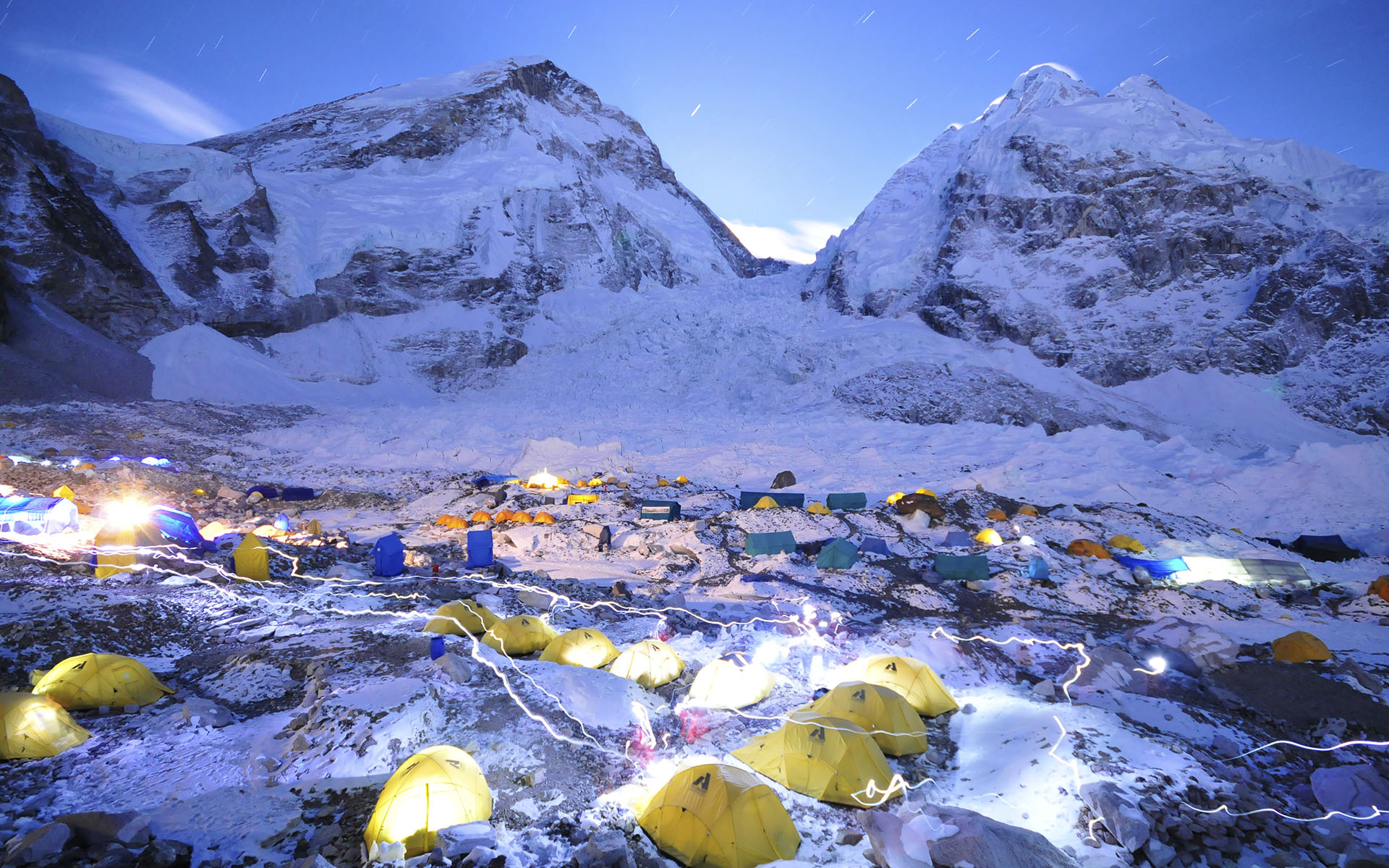
To go on to foot of Everest Basecamp, continue north from Pheriche along the flats past the yarsa of Phuling, then turn northeast up the khumbu glacier. The route cross its crest, descends to cross a glacial stream emerging from the snout of glacier, which is covered by the moraine (4579m), and descends to the huts of Thukla (4593m). It takes 1/5 hours to reach Thukla from Pheriche, climb to pass to the right of right stone memorials on a right crest. There are built for climbers killed on expeditions to nearby summits, mostly everest. The trail then contours on the other side of the glacier after crossing another stream of melted water. The trail heads northeast. There are so many lodges accommodation of Labuche (4930m).
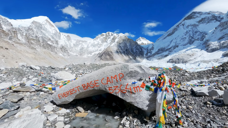
This is certainly one of the most malestic mountain viewpoints in the world. The sites of the various base camp used for climbing Everest are closed to the foot for the khumbu icefall (5357m) and can be reached from Gorakshep in a few hours by venturing over the rubble covered surface of the khumbu glacier. As you approach the first evidence of base camp garbage, note that recent base camps are an hour or so beyond, right at the foot of the khumbu icefall. If you are here when no expedition is climbing everest, It may by tedious and time consuming to find the exact location. It is possible to visit the basecamp from Lobuche and return the same long way. There are no good views from the base camp and little reason to go if visiting this area is not important to you. If time limited, its better to ascend to Kalapathar. Better views of the khumbu icefall and the other side of the Lhotse-Nuptse.
TO LOWER SOLU AND EVEREST TREKKING

Reach Dingboche as already decribed or climb up the ridge (4343m) behind Pheriche and descend to it in half an hour. You can take a shortcut from Labuche by crossing the stream emanating from the snout of the khumbu glacier and climbing up the lateral moraine. Then follow a trail that contours to the south, passing the small temporary village of Dusa before dropping down to Dingboche. From Dingboche at bibre 1/5 half hour but (4571m). Bibre is reached in 1/5 half hour from Dingboche by the direct route.
The trail continues east, crossingg numerous streams that flow from the Nuptse abd Lhotse glacier, to a number of yak huts or years at Chhukung (4734m), perhaps 1/5 hours after Bibre. You can see Ama Dablam east face.Its worthwhile to spend a day or two travelling around to the east and to the northeast for close views of the incredible Lhotse and Nuptsewall. Either the khumbu himal or the Mahalangur Himal map veru useful here and suggest many hikes. Imja Tse (Island Peak), a trekking summit is northeast.
Kumjung and Khunde
The stol strip called Syangboche (3720m) is carved out of a sheld of land. Reach it less than an hour from Namche Bazaar, taking the trail that climb past the gomba. There are hotels and restaurents. The government yak breeding farm five to ten minutes to the northwest is recognized by an impressive fence enclosing it. Often the yaks and naks (Females) may be pastured much higher. The farm is attempting to preserve and maintain good genetic stocks necessary for the cross-breeding programs in which heart Chauri (cross between cow and yak) are developed. You can proceed past the preserve to the northwest, climbing to a crest (3871m) in peaceful juniper forest and descemding to khumbu (3841m) the north end of this village is the site of Khunde hospital, built by himalayan trust established by sir Edmund Hillary. To reach khumjung, the sister village of khunde. You can either taverse east from khunde.
Or go directly from Syangboche by climbing northeast from the strip past a large chorten in ablue pine forest.Descend past the Himalayan Trust Secondary High School khunde to the potato fields below Khumjung (3780m). A village gomba in a juniper grove to the north contains yeti relics that can be seen for a donation. The yeti scalp has been sent around the world for a lest of its authenticity. Reach high in the thin cold air by sir Edmund Hillary and Desmond Doig (Garden city, New York Doublieday, 1982) for details. The faned sherpa artist kappa pasang lives in Kumjung.
Of final interest is the now closed Everest view hotel, beautiful situated on a shelf (3870m). It can be reached in half an hour or less from the airport by following the well graded path beginning at the lower end to the airport. Or you cab reach it from the stupa at the eastern end potato fields of Khumjung. Much has changed in the area every year.
Kumjung and Khunde

Mana landslides have occurred on both sides of this steep valley. After emerging from the woods, the trail passes several summer yak herding huts, of years, including Tongba (4015m) Gyele, and Dole (4084m), It takes 1 an half hour from stupa on the ridge crest to Gyele. The next yersa at Lhabarma is far fromwater, but it is available at the one after that, Luza. Because this valley has been developed traditional resting points, such as Pheriche on the way to the foot of Everest, people are ascending too rapidly. Seriously altitude illness in occurring more often here, while the incidence on the way to the Everest has declined. Be prudent and take time to rest a day or two.
The trip up the Dudhkosi from Khumjung takes you to summer yak-grazing country, to beautiful small lakes and to the foot of Cho Oyu and Gyachung Kang peaks. Trail goes northeast of stupa at the east end of Khumjung and climbs along the side of khumbiyula crossing a rocky prominence to a crest of a ridge (3992m) where there is a stupa. This takes two hours from khumjung. Above you on the slopes of khumbiyula watch for a herd Himalayan thar (mountain goats), locals. Phortse is is across the river. The rail descends steeply to near the river (3643m). take the left fork at junction, as those to the right descend and cross the river to Phortse. The trail heads north and after an hour or so, Cho Oyu is visible. You cross many spectacular waterfalls that are frozen in winter.
From Gyele, Lhabarma (4328m) is reached in less than hour and Luza (4390m) is another hour. In the next tributary valley is Machherma (4465m), another forty five minutes away. Go on for an hour to pangka (4548m) but here again. There is water near. From pangka, descend slightly, following one of the melted glacial rivers that flow down the west side of the Ngozumpa glacier, which is to the east now. The trail crosses this river at a narrowing and soon emerges at the first of several small lakes (4709m) 1/5 hours beyond pangkaa. Another forty five minutes brings you to the next lakes or tsho, with the longpanga at its northern end. There is no good shelter here, so continue for another half hour to the third lake ( sometimes called Dudh pokhari) and the years of Gokyo (4791m) on its east-from Gokyo, Cho oyu looks to the north. There are several places to go for views. Currently the most popular is to ascend the ridge to the northwest to a small summit (5483m). this climb takes 2 to 3 hours for those well acclimatized and provides an excellent panorama Cho Oyu, to Everest, Lhotse and all the way to Makalu. Some trekkers consider the view from the Kalapathar, as it is called, better then from the one above Gorakshep. Alternatively, you can follow the trail north between the lateral moraine of the glacier and the hills to the west until you reach the next lake (4923m) where, near its east shore there are some roofless huts about 1/5 hours from Gokyo. A climb of a few hundred feet up the hill to the north of the lake provides fine views. You could also continue another 1/5 hours to the last lake. The khumbu himal map may suggest many other hikes. You could return from Gokyo by following the east side of the valley, reaching it from below the snout of the glacier at pangka. Or you could cross the glacier directly east of Gokyo. Alternatively, you can way back to Dole and Machherma Namche bazaar Lukla/ fly back Kathmandu.